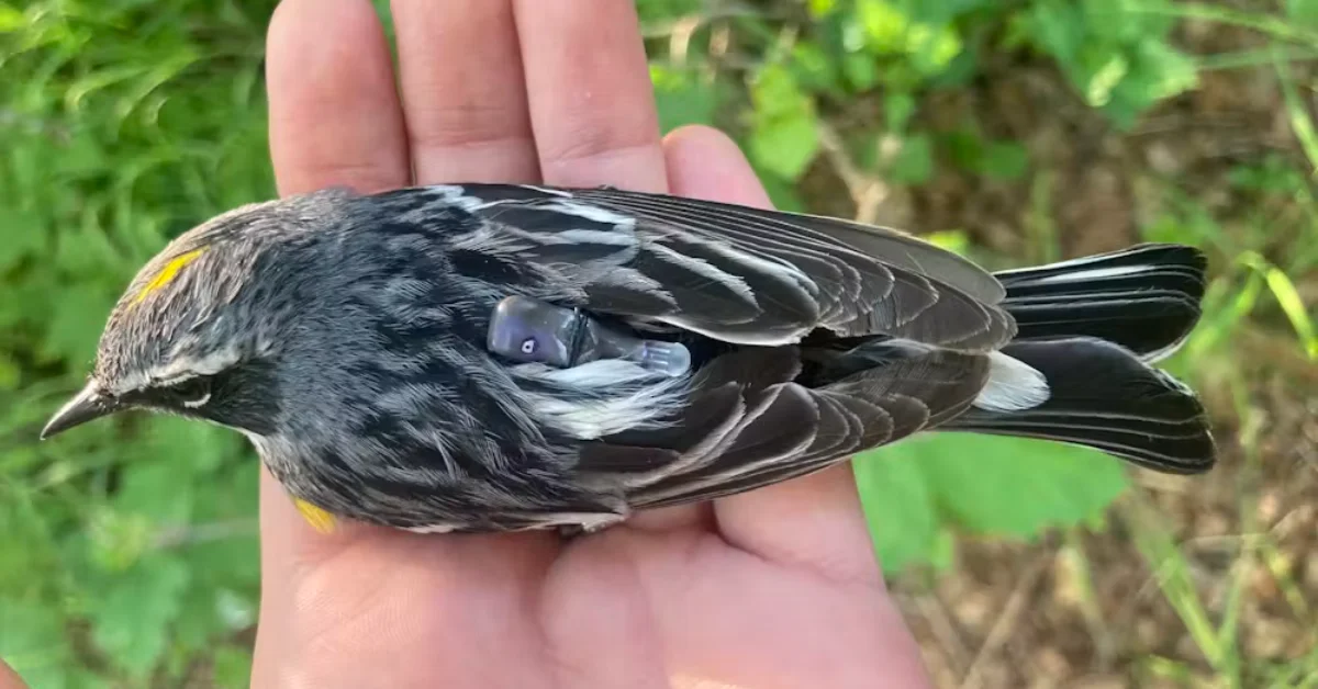
Squinting through my binoculars, I scanned the dense branches of a black spruce, trying my best to catch a glimpse of the thin legs of a small black, white, and yellow songbird. I was on the hunt for a yellow-rumped warbler — a bird affectionately called “butter-butt” by bird-watchers after the distinctive buttery yellow patch of feathers above its tail.
Once I spotted a flash of red on one of the bird’s legs, I knew that this individual was special — in fact, it was one that I already knew well. That’s because I had placed identifying bands on it the previous year as part of my Ph.D. research, and it was carrying a very important piece of new technology.

I played the high pitched “warble” of its song through a speaker placed below a mist net of fine, nearly invisible mesh. Thinking another male had intruded on his territory, the bird quickly descended. My tactic worked — he got caught in the net.
As I gently removed him, I breathed a sigh of relief as I saw the Tic Tac-size device sitting on his back.
Over the past year, this warbler carried a multi-sensor geolocator backpack throughout his migratory journey, recording the long trek from his breeding grounds in Anchorage, Alaska, to a yet unknown winter refuge and back again.
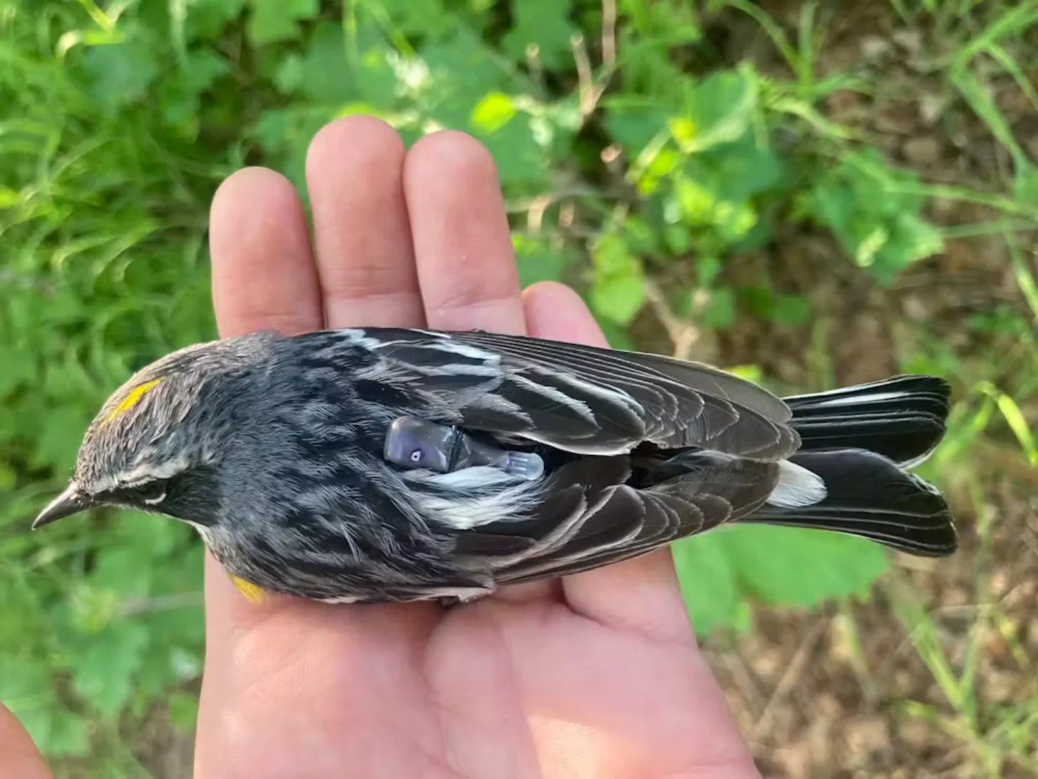
Working with my Ph.D. adviser, evolutionary biologist David Toews, I deployed dozens of these cutting-edge tags to illuminate the migratory journeys of these high-latitude breeding warblers at a scale not previously possible for small birds.
Now, after a year of waiting, I finally had the data in hand.
How can scientists track small birds?
Researchers began tracking the movements of migrating birds in the late 1960s using radio telemetry, a technique that requires tagged birds to be physically followed with receiver equipment, sometimes aided by a small aircraft.
Then, as GPS became more widely available in the early 2000s, satellite tags let researchers accurately track birds remotely. However, GPS transmitters are hefty — even just the battery that powers them is too heavy to be carried by the majority of small migratory songbirds, which often weigh less than a spoonful of sugar.
To address this problem, researchers developed ingenious little light-level geolocators.
These miniature tags minimize weight by containing only a tiny battery, clock, computer chip, and light sensor. They store data internally rather than transmitting it — hence my need to recapture tagged birds a year later. Researchers infer a bird’s locations from the timing of sunrise and sunset, which vary predictably across the globe and throughout the year.
Light-level geolocators have opened new windows into the migrations of small birds, but they also have limitations: Their estimated locations can err by hundreds of miles, and this uncertainty becomes impractically high around the equinoxes, when day length is the same worldwide.
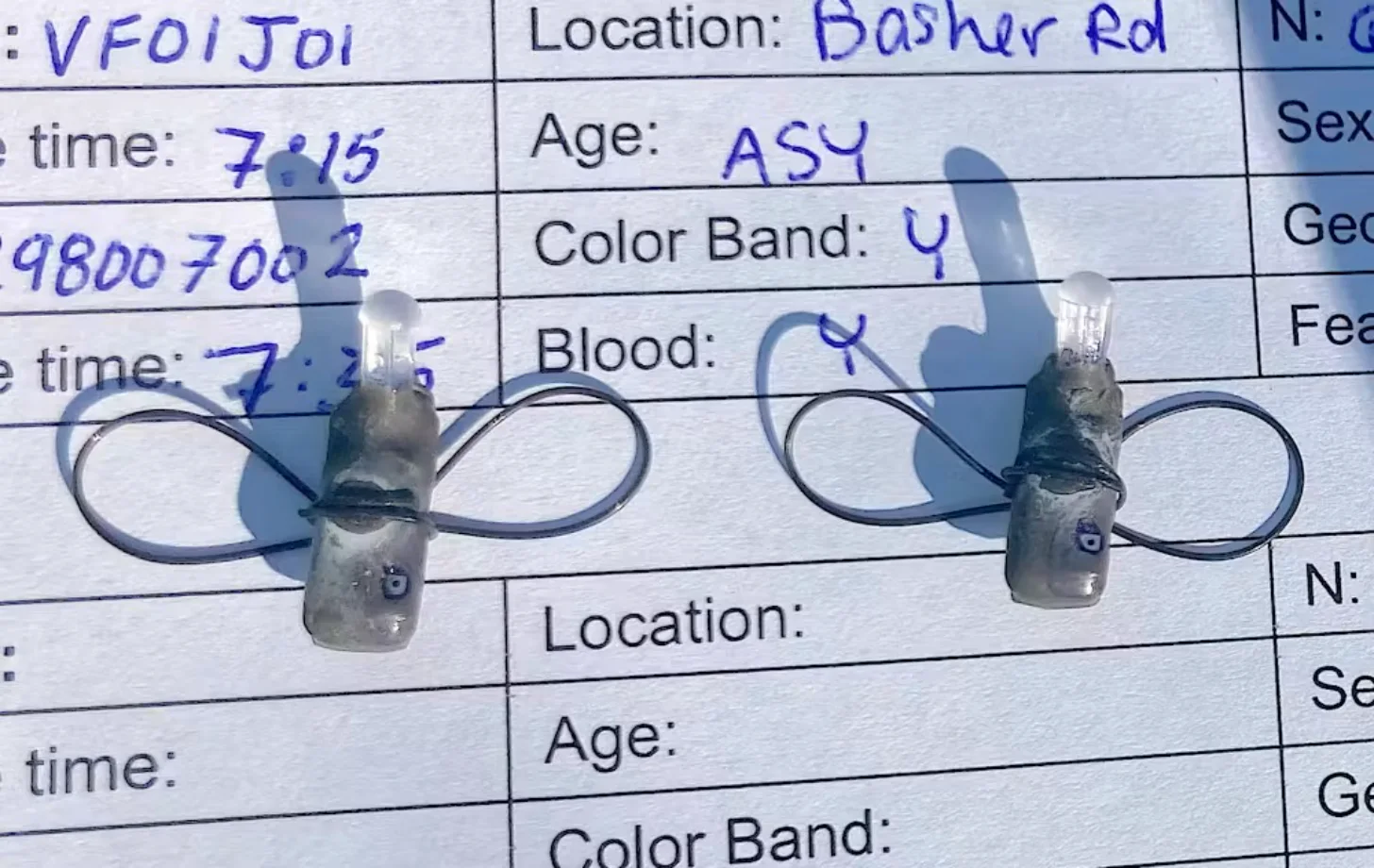
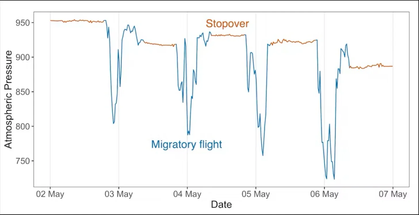
More recently, researchers developed a newer method of geolocation that uses atmospheric pressure to circumvent these limitations. When a bird ascends during a migratory flight, a barometric geolocator records a steep drop in air pressure, capturing the timing of departure and arrival for every stop along a bird’s migration route.
In between flights, the pressure the tag records reflects the elevation at the bird’s position.
Knowing the bird’s elevation helps to narrow down possible locations, which researchers can then refine further by comparing the change in pressure over time recorded by the tag to global weather data using the computer program GeoPressureR. The unique pattern of rises and falls in pressure acts as a kind of pressure fingerprint for a specific location. Including light and wind data in the model of the bird’s movements can increase precision even more.
New tech answers an old question
We used these new multi-sensor backpacks to study the migration patterns of myrtle warblers, the northern subspecies of yellow-rumped warbler, which breed across North America’s boreal forest.
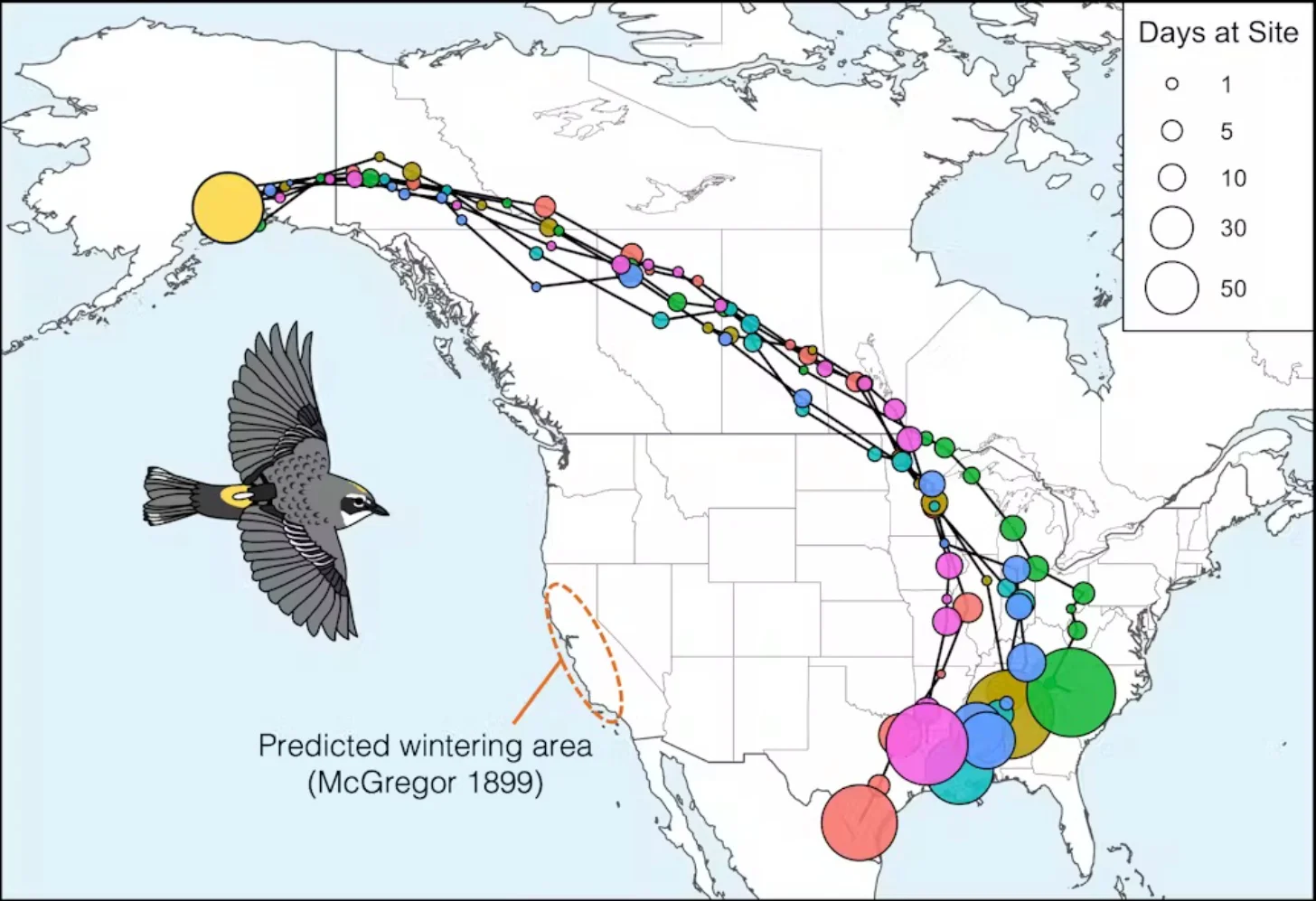
Myrtle warblers in the northeast are known to winter along the Atlantic and Gulf coasts, but where northwestern populations migrate has been more of a mystery. In 1899, ornithologist Richard McGregor observed myrtle warblers wintering in coastal California, and hypothesized that these birds might breed in Alaska and British Columbia.
Using these new tags allowed us to test whether warblers breeding in Anchorage, Alaska, actually followed the shortest migration route to winter in California. To our surprise — and probably to McGregor’s as well, if he were still alive — we found that all the birds we tracked traveled east across the boreal forest of Canada before shifting south to the Gulf Coast — certainly not the Pacific Coast route we expected.
All told, this 6,800-mile round-trip journey was much longer than we anticipated for a species commonly considered a short- or medium-distance migrant.
Why take such a circuitous route?
The long, seemingly suboptimal route taken by our Alaskan myrtle warblers is actually mirrored by some other songbird species tracked from northwestern North America, including blackpoll warblers and Swainson’s thrushes.
Part of this pattern may relate back to the glaciations that isolated ancient populations of birds millions of years ago. The thinking goes that as these glaciers spread, they squashed the ranges of formerly northern species into the south. Then, as the glaciers slowly receded, the forests gradually re-expanded.
As more land opened up, birds moved farther north and west into that habitat. Each season, some birds went a little farther as the forest available in their northern breeding grounds expanded.
For migratory species such as myrtle warblers, the farther north and west their breeding range expanded, the longer the migration to their southern wintering ground became.
Scientists think migration routes are genetically encoded. The birds’ genes may have traced this expansion front, like Hansel and Gretel putting down breadcrumbs as they journeyed deeper and deeper into the forest.
Today’s migration routes still trace that incrementally expanded path, even though the glaciers that shaped the original boundaries are long gone.
We’re still not sure exactly where the California-wintering myrtle warblers spotted in the 1800s are breeding. We suspect that a small proportion of the Anchorage-breeding birds may migrate to California, but that most of them travel from more distant, unstudied regions of Alaska or Yukon.
Future research, potentially tagging myrtle warblers directly on the California wintering grounds, will shed more light on this population and why certain individuals follow a different migration route.
Barometric geolocation provides new data
Today, this new geolocation approach improves scientists’ ability to study the migrations of small birds and supports more effective conservation actions across the course of the entire year.
More precise location estimates help researchers identify key stopover and wintering sites in need of protection and better understand the threats birds face throughout their journeys. These geolocators also reveal the altitude of migratory flights, which is important for understanding the risk of birds colliding with buildings or wind turbines.
Because these new tags capture pressure data for every migratory flight, they’re especially valuable for studying migration timing. Researchers have combined data from over 50 bird species to understand at what time of day or night different birds migrate.
Now, as a postdoctoral researcher at the Smithsonian Migratory Bird Center, I am integrating multi-sensor geolocator data with satellite imagery to investigate how arrival and departure decisions throughout a bird’s migratory journey relate to seasonal changes in plant growth.
Scientists have now tracked dozens of bird species with multi-sensor geolocators, and that number increases every year. Each mapped migratory journey improves our understanding of how small birds migrate, what factors shape their movements, and how best to protect them.
This article was written by Stephanie Szarmach from the Smithsonian Institute and was originally published on The Conversation.

Featured Image: Stephanie Szarmach